ॐ
Kedarnath Temple
Shri Kedarnath · 11th Jyotirlinga · Garhwal Himalayas, Uttarakhand
॥ ॐ नमः शिवाय ॥
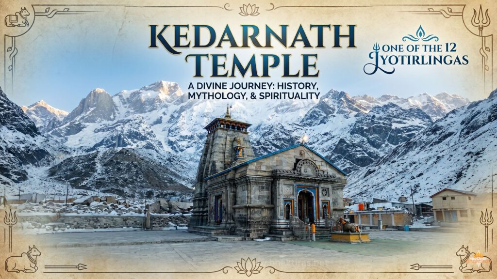
Kedarnath is the highest of the twelve Jyotirlingas, standing at about 3,583 metres in the Garhwal Himalayas of Uttarakhand. Reached only on foot, by pony or by helicopter, the stone temple sits beneath snow peaks at the head of the Mandakini valley and is open for barely six months of the year. It is also one of the Chota Char Dham and the chief of the Panch Kedar.
The highest Jyotirlinga
Set against the Kedarnath peak, the temple enshrines a conical rock as the Jyotirlinga rather than a carved lingam. Its remote, high-altitude setting and short season make a darshan here one of the most demanding and prized in the Shaiva tradition.
Legend and Adi Shankara
In the Mahabharata tradition the Pandavas sought Shiva here to be absolved after the war; the Lord, eluding them as a bull, left his hump at Kedarnath, worshipped ever since. The present temple is credited to Adi Shankaracharya, said to have revived the shrine in the 8th century and to have attained his end nearby.
Architecture
Built from massive interlocking grey stone slabs without mortar, the temple has withstood centuries of snow, ice and flood in one of the harshest settings of any Indian shrine. Its plain, deliberate strength is suited to the mountains around it.
The 2013 floods
In the disaster of June 2013, flood and debris swept the town, yet the temple itself stood — shielded in part by a large boulder, now revered as the Bhim Shila, that split the flow behind the sanctum. Its survival deepened the shrine’s hold on devotees.
The yatra and the season
Kedarnath opens around late April or early May, on Akshaya Tritiya, and closes near Diwali, after which the deity is worshipped through winter at Ukhimath. The temple is reached by a trek of roughly 16–18 km from Gaurikund, with pony, palanquin and helicopter options.
Darshan timings
During the open season the temple is generally accessible from about 4:00 am to 9:00 pm, with a midday break for rituals. Plan for cold, thin air and sudden weather; warm clothing and a slow, steady pace are essential.
How to reach Kedarnath
- By road + trek: the 16–18 km trek begins at Gaurikund, reached by road from Rishikesh and Haridwar via Sonprayag.
- By train: Rishikesh (~210 km from Gaurikund) is the nearest railhead.
- By air: Dehradun (Jolly Grant); helicopters run from Phata, Sersi and Guptkashi.
Tips for your visit
- Book the yatra registration and any helicopter slot well in advance.
- Carry warm layers, rain protection and basic altitude medicine.
- Start the trek early in the day.
- Respect the short season and all weather advisories.
Frequently Asked Questions
Why is Kedarnath called the highest Jyotirlinga?
It stands at about 3,583 metres in the Garhwal Himalayas, the highest in altitude of the twelve Jyotirlingas.
When is Kedarnath open?
Roughly from late April or early May (Akshaya Tritiya) to around Diwali; in winter the deity is worshipped at Ukhimath.
How do I reach the temple?
By a trek of about 16–18 km from Gaurikund, with pony, palanquin or helicopter options; Gaurikund is reached by road from Rishikesh and Haridwar.
What happened to the temple in the 2013 floods?
The town was devastated, but the temple stood, shielded in part by a large boulder behind it now revered as the Bhim Shila.
What form is the lingam at Kedarnath?
It is a conical rock, worshipped as the hump of Shiva in his bull form, rather than a carved lingam.
What should I prepare for the Kedarnath yatra?
Cold, thin mountain air and changeable weather; carry warm layers and rain gear, register for the yatra, and pace yourself for the altitude.
॥ हर हर महादेव ॥ • Bhaktiras.net Temple Guide
| Temple Name | Kedarnath Temple |
| Primary Deity | Lord Shiva (Kedarnath) |
| Location | Kedarnath |
| District | Rudraprayag |
| State | Uttarakhand |
| Significance | 11th Jyotirlinga & Chota Char Dham |
| Architecture Style | Nagara (stone) |
| Approximate Period | 8th century (Adi Shankara) |
| Key Festival | Kedarnath Yatra (May–Oct) |
| River / Body Nearby | Mandakini River |
| Special Features | Highest Jyotirlinga (3,583 m) |
| Darshan | 4:00 AM – 9:00 PM (season) |
| Nearest Railhead | Rishikesh (~210 km) |
| Coordinates | 30.7352° N, 79.0669° E |
| Entry | Free (yatra registration required) |
Related Temples
Explore more sacred temples connected by deity and region.